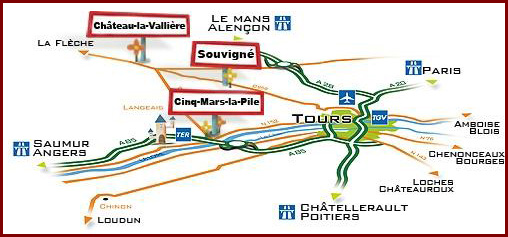
How to find us ?
We are 30 kms from Tours train station, and 20 kms from Tours Val de Loire Airport.
We are 15 kms from the A28 motorway.
By car: GPS coordinates
Latitude : 47.522997 / Longitude : 0.389156
From Paris or Bordeaux, get off the A28 motorway at junction 27, signposted " Neuillé Pont Pierre", then head towards Château la Vallière, and then Souvigné D959. At the roundabout upon arriving in Souvigné, turn right towards Courcelles de Touraine, then first right, and after a few more metres you will have reached your destination !
From Tours, head towards Saint Cyr sur Loire, and then La Membrolle sur Choisille. Continue along the D959 towards Angers/Château la Vallière. At the roundabout upon arriving in Souvigné, turn left towards Courcelles de Touraine, then first right, and after a few more metres you will have reached your destination !